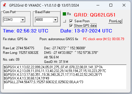
GPS2Grid utility by VK4ADC
July 2024
 |
 |
GPS2Grid is a utility for Win 7 to 11 (32 OR 64 bit versions) that calculates the Maidenhead Grid Locator value from the GPS serial data supplied via a COM port. It does NOT provide clock correction options - that is what my GPS2Time utility does - but does display the clock error in MM.SS.zz format on screen. (where the zz is decimals of a second..)
Please note that if you have a GPS device (/dongle) that has not been in use very recently, it can take quite a few MINUTES once it is powered up before it provides useful GPS data. This state is obvious if you select the tick box to "Show GPS data" and you mainly see a series of commas in the displayed data. Once the receiver has completed a self-survey, those commas become interspersed with numbers/characters.
Note that the grid square detail will NOT be filled in until a number of satellites are in "view" of the GPS receiver, with the higher satellite count extending the accuracy of the detail.
There is no installation process. Simply extract the zip file into a new folder (eg C:\GPS2Grid ), right click on the GPS2Grid.exe file and select the 'Send to Desktop' option. (in Win11, this is under the "more options" menu that appears).
In some cases, you might get an antivirus message but let it run anyway. It does not contain web support code and can create and update three text files in the program's executable folder : "GPS2Grid Version.txt", 'Posnlog.txt' and 'GPSDATA.txt', and nothing else. The software settings are saved in the Windows registry (rather than an INI file) so that every computer it is run on has it's own distinct setup.
The user will need to select a/the COM port that the GPS receiver is connected to. The software scans for available ports and it will be obvious when the correct port is selected as the 'Rx' indicator will flash from green to red briefly once a second. The background colour of the COM box will also change to green.
The Baud value will need to be set to match the GPS device but typically 4800 is supported by all current models. If the GPS data window does NOT contain text like in the image above, only then alter the baud setting.
There is a values/position reset option available via the command line. Edit the shortcut so that it then shows as 'GPS2Grid.exe /RESET' in the command box, run the software and then later remove the /RESET text.
There is no "help file" but most controls have 'hover' help hints.
Version details : GPS2Grid version.txt (< 1KB) { view this first to see if a later version than you already have is available, actually about 9 bytes in size }
The software can be downloaded from this link : GPS2Grid.zip
Current size of the zip is about 320KB and expands to just under 700KB.
While I try to catch any coding errors, there is always the possibility that someone somewhere will do something I have not forseen : the outcome is... no warranty provided or implied.
Doug VK4ADC
Notes:
As from version 1.1.0.5, two command line options are available..
/XG (for Xtended Grid detail) which allows for two more maidenhead characters to be visible, eg QG62LG51ET, but there needs to be at least 9 sattellites to be in view before the extra grid details are available.
/AV (for AVerage lat/long values) which shows a calculated average of lat and long values rather than the constantly varying immediate values direct from GPS data.
